Last updated: June 2026 — seasonal dates and logistics verified June 2026.
Vietnam has hundreds of rice terrace sites. Mù Cang Chải is different. The scale is different — 2,200 hectares across a mountain range, not a single hillside. The elevation is different — 1,000m means morning mist that Sapa’s lower terraces don’t produce in the same way. And the degree of development is different: this is still primarily a working agricultural district with a tourism infrastructure built around it rather than over it.
This guide covers the terraces specifically: what they are, where they are, how each season looks, and what to do when you get there.
What Makes Mù Cang Chải Different from Sapa
The comparison comes up constantly. Both are in northwestern Vietnam, both have H’Mông communities, both have rice terraces. The differences matter:
Scale and remoteness: Mù Cang Chải district is 300km from Hanoi — further, and accessible only by bus. Sapa is 330km but has a direct overnight train and an airport 30km away. The extra friction filters out day-trippers and casual visitors, which means Mù Cang Chải has a fundamentally different crowd density at the viewpoints.
Terrace character: Sapa’s terraces are impressive but heavily photographed and surrounded by visible tourism development — cable cars, resort hotels, organized trekking operators on every corner. Mù Cang Chải’s terraces are larger, less manicured, and still look like what they are: a working agricultural system on a mountain that farming families happen to live on.
Season dependency: Both destinations have peak seasons, but Mù Cang Chải’s golden harvest is more strictly timed than Sapa’s. Miss the two-to-three week window and there is no consolation prize. Sapa has more varied terrain and activities that work outside the rice terrace peak. Mù Cang Chải is almost entirely about the terraces — which means getting the timing right matters more here.
⚠Real Talk
Sapa is easier, more comfortable, and has better tourist infrastructure. Mù Cang Chải has a rawer, more dramatic landscape and dramatically fewer tourists. If you want a mountain community destination with good guesthouses and English-speaking guides, go to Sapa. If you want the best rice terrace photographs and don’t mind an overnight bus and an uncomfortable homestay, come here.
The Three Terrace Areas
The 2,200 hectares designated as National Scenic Heritage are concentrated in three communes, each with a different character and access situation:
La Pan Tán — The Most Photographed
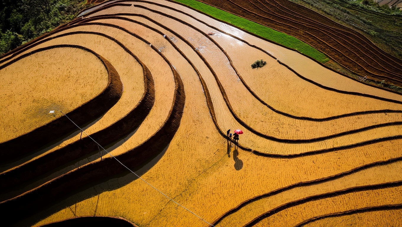
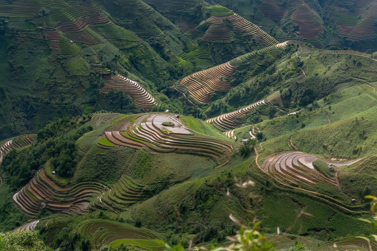
La Pan Tán (say: la pan tan) is 18km from Mù Cang Chải town on the road toward Tú Lệ. This is where the postcard images come from — the Mâm Xôi Hill viewpoint is here, the largest and most accessible terrace faces are here, and the road along the ridge gives views in both directions for several kilometers.
The terraces at La Pan Tán step down from the ridge road into broad valleys on both sides. At harvest, the scale is overwhelming in a way that photographs don’t quite convey — the terraces continue for several kilometers in every direction, and the color variation across different fields (some cut, some still standing, some a few days from peak) creates the kind of compositional richness that photographers specifically come for.
Most visitors stay within 2km of the Mâm Xôi Hill entrance. Walk further in either direction along the ridge road and you’ll find fewer people and equally good or better views from lower angles. The ridge road itself, from about km 14 to km 20 out of Mù Cang Chải town, runs along the spine of the terrace system and gives unobstructed views into both valley sides simultaneously. This stretch of road at 5pm in harvest season is one of the most visually concentrated experiences in northern Vietnam — the terraces catch the low western light from behind you, the shadows fall into the terrace wall crevices, and the color deepens as the sun drops. No entry fee. No ticket booth. Just the road and the view.
Che Cu Nha — The Trekking Area
Che Cu Nha (say: che koo nya) is 15km from town in the opposite direction from La Pan Tán, requiring a separate ride. The terrace topography here is narrower and more deeply folded — the fields descend into tight valleys rather than open slopes, and the walking paths between villages are what make this area worth the trip, not the viewpoints.
This is where to hire a guide and spend a full day on foot. The path network through Che Cu Nha connects H’Mông villages across terrain that motorbikes can’t navigate — rice paddy walls 60cm wide over steep drops, river crossings on bamboo bridges, forests between the cleared terrace sections. The guide knows which families will offer you tea and which paths are seasonal. You don’t.
Dế Xu Phình — The Remote Option
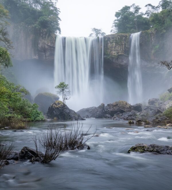
Dế Xu Phình (say: day soo fin) is the furthest and least visited of the three. The terraces here are less accessible from the road — you find viewpoints by riding until the ridge opens up rather than following signs to an established platform. The village at the center of the commune sees very few foreign visitors. The light in the late afternoon on the Dế Xu Phình valley face is excellent and underutilized.
The Three Rice Terrace Seasons
Understanding the seasons is the central planning question for a Mù Cang Chải trip. The same physical landscape looks completely different in each season, and each has a different photographic quality and crowd level.
Water Pouring Season — Late May to Mid-June
Farmers flood the terraces to prepare for planting. The fields fill with water and become mirrors reflecting the sky — on clear mornings the effect is the most photographically unusual of the three seasons. Blue sky and white clouds reflected in amber-brown terraced mirrors, with the mountains above and the valley below. The light is different from harvest season — sharper, less warm — and the visual grammar is completely different: horizontal planes of reflection rather than cascading gold.
Crowd level: significantly lower than harvest. The water season doesn’t have the same cultural cachet as harvest gold, so tour groups are fewer. This is the better season for anyone who wants the landscape with space to move in it.
Weather note for water season: late May and early June can bring afternoon cloud cover and occasional rain. The morning window — roughly 6am to 9am before cloud builds — is the critical photography period. Arrive the night before, stay in La Pan Tán, and you’re positioned correctly. If you stay in Mù Cang Chải town, the 18km morning ride may eat into your window. The flooded terraces need clear sky for the mirror effect — overcast mornings produce a flat grey reflection instead of blue sky and cloud. Check the forecast and plan your best-light mornings around it.
Green Growth Season — July to August
The rice is planted and growing. The saturation of green at this elevation — almost fluorescent in some morning light conditions — is its own visual experience. Photography is harder than in the other two seasons because green terraces are harder to separate tonally from the surrounding forest, and the mist is heavier and more persistent in summer. But for trekking and village exploration, this is the right season: the paths are accessible, the weather is warm, and the community is actively working the fields rather than harvesting.
Golden Harvest — Mid-September to Mid-October
This is the peak. The rice ripens from green through amber to deep gold, and the progression moves down the mountain as the season advances — higher terraces turn earlier, lower ones later, giving a two-to-three week window during which at least some part of the landscape is at peak color. The light quality in September–October, combined with the harvest color and the morning mist that still comes off the valleys, produces conditions that wildlife and landscape photographers travel from across Asia to capture.
Crowd level: highest. Domestic Vietnamese tourists, international photographers, organized tour groups. The Mâm Xôi Hill viewpoint on a Saturday in early October will have people queuing for the platform spots. Go on a weekday. Go before 7am. The experience at 6am is categorically different from the experience at 10am on the same day in the same place.
ℹKnow Before You Go
The exact golden peak shifts year to year based on monsoon timing. In a late-monsoon year, peak can arrive in early October rather than late September. Check recent Instagram posts tagged #mucangchai in the week before your planned visit — you’ll see current color levels from people already there. No guide’s fixed dates are as reliable as what travelers posted three days ago.
Mâm Xôi Hill — Viewpoint Logistics
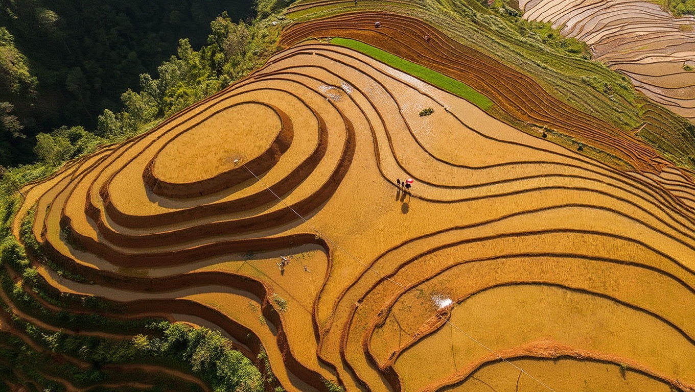
Mâm Xôi (say: mam soy) is the signature viewpoint and the image that defines Mù Cang Chải in international travel media. A rounded hillock at the center of a bowl of terraces in La Pan Tán commune, surrounded by fields on all sides at every angle from the viewing platforms above it.
Entry fee: 20,000 VND (~$0.80) adults, 10,000 VND (~$0.40) children. Photography platform surcharge: 5,000 VND (~$0.20). Walking down into the rice field area: 10,000 VND (~$0.40) additional.
Opening hours: The site is accessible from before dawn — no enforced opening time in practice for early arrivals. The ticket booth opens around 7am; if you arrive earlier, wait for it to open or pay when you leave. No one will stop you from entering before the booth is staffed.
Viewpoint platforms: Three levels on the hillside above Mâm Xôi. The mid-level platform gives the classic wide-angle view with the hill in the foreground and terraces extending behind it. The upper platform gives compression for telephoto shooting. The lower area near the field entrance gives the ground-level terrace-wall perspective. Each has different value depending on what you’re photographing.
Who Built the Terraces
The H’Mông (say: hmong) people who built and maintain these terraces are among Vietnam’s largest ethnic minority groups, concentrated in the northwestern mountains. The terraces were constructed over generations — no mechanization, no outside engineering, just accumulated knowledge about slope management, water routing, and soil preparation passed between families across centuries.
The irrigation system that fills the terraces each May is gravity-fed — water diverted from mountain streams through channels built into the hillside, flowing from the highest fields down through every level to the valley. The maintenance required to keep this system functioning is continuous: channels clear of debris, terrace walls structurally sound, water flow balanced across the entire network. A family’s terrace area is their annual food supply and their inheritance.
This context matters for how you visit. The terraces are not a preserved cultural landscape — they’re active farmland that someone is currently working. The women walking on the narrow terrace walls with baskets of rice are doing their job, not performing for visitors. Photography is fine; interference is not. Stay on the paths. Don’t walk on the terrace walls. If you’re not sure whether a path crosses private farmland, ask your guide or the homestay host before you go.
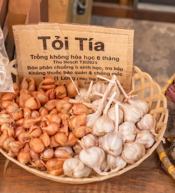
The H’Mông in Mù Cang Chải are predominantly Black H’Mông — identifiable by the dark indigo-dyed clothing that the women wear. The dyeing process uses batik techniques with beeswax resist and natural indigo, producing the deep blue-black color that’s both culturally significant and functionally waterproof in mountain conditions. The fabric is hand-woven and hand-dyed; the indigo smell is distinctive and pervasive in the villages during dye season. Women who sell fabric and clothing at the Saturday market in town are selling the same product they use themselves — it’s not souvenir craft, it’s working clothing.
Small purchases at the market — indigo cloth, hand-stitched pouches, sticky rice — go directly to the families who made them. There are no middlemen at the Mù Cang Chải Saturday market yet. This will change as the tourism infrastructure develops. Buy now while the transaction is still honest.
Getting Around the Three Terrace Areas
The three communes are not connected on a single loop — each requires a separate out-and-back ride from Mù Cang Chải town. Plan accordingly:
La Pan Tán: 18km from town on the road northwest toward Tú Lệ. Paved, good condition, manageable gradient. Takes 25–35 minutes. Stay here if you want dawn access without the ride — La Pan Tán homestays put you inside the terraces rather than 18km away.
12Go covers most Vietnam routes — sleeper buses, trains, and island ferries. Compare schedules and book in advance during peak season (Dec–Feb, Jun–Aug).
Che Cu Nha: 15km from town in the opposite direction, southeast. Also paved and accessible on a semi-automatic motorbike. The village area requires walking or a local guide once you leave the main road — this is not a viewpoint you drive to, it’s a trekking area you walk into.
Dế Xu Phình: Northwest from town, roughly 20km, with a road that narrows after the first 15km. The surface is paved but has rough patches. Allow 45 minutes each way. Most visitors combine Dế Xu Phình with La Pan Tán on the same day since they’re in roughly the same direction — La Pan Tán dawn, return to town for lunch, ride to Dế Xu Phình for afternoon light.
Motorbike rental: 100,000–150,000 VND (~$4–6) per day in Mù Cang Chải town. Semi-automatic is the right choice for all three areas — the gradient on the approach roads requires gear control, and manual bikes are harder to manage on steep unfamiliar mountain roads. Check the brakes before you accept the bike. Fuel up in town before you ride out — no petrol stations beyond the 5km mark on any of the three routes.
Walking within the areas: Possible at La Pan Tán and Che Cu Nha, though the distances between viewpoints are significant (2–5km). The Che Cu Nha trekking area specifically rewards walking over riding — hire a guide from the village (300,000–500,000 VND/day) for the path network that motorbikes can’t navigate.
For the full guide to visiting, planning, and getting there, the Mù Cang Chải travel guide covers transport, accommodation, and how to structure your time across the three terrace areas.
Frequently Asked Questions
When is the best time to see the Mù Cang Chải rice terraces?
For golden harvest color: mid-September to mid-October — approximately 2–3 weeks at peak. For water reflection photographs: late May to mid-June. For trekking through green rice growth: July to August. Avoid November through April — the terraces are bare and there’s nothing to see. The exact harvest dates shift by 1–2 weeks depending on the monsoon timing each year.
How large are the Mù Cang Chải rice terraces?
2,200 hectares of terraced rice fields designated as a National Scenic Heritage Site, spread across three main communes: La Pan Tán, Che Cu Nha, and Dế Xu Phình. The terraces step down from ridge lines at roughly 1,200m to valley floors at around 700m. At ground level, individual terrace walls range from knee height to over 2m where the gradient is steepest.
Is Mù Cang Chải a UNESCO site?
No — Mù Cang Chải is designated as a Vietnamese National Scenic Heritage Site (Di tích Quốc gia đặc biệt), not a UNESCO World Heritage Site. UNESCO recognition has been proposed but not granted. The domestic heritage designation provides some protection but the terraces remain working farmland rather than a preserved museum landscape.
Can I walk on the rice terraces?
In designated areas, yes — the 10,000 VND entry to walk in the rice field area at Mâm Xôi permits path walking within the terrace area. Outside designated areas, the terrace paths are private farmland. Walking on the terrace walls damages them — stay on footpaths. If you hire a local guide for trekking in Che Cu Nha, they’ll keep you on appropriate routes.
Two things worth sorting before you land: a Vietnam eSIM so you have data the moment you clear customs, and travel insurance — medical costs for uninsured foreigners in Vietnam are significant.
Airalo eSIMs activate instantly. Buy before departure — airport SIM queues in Vietnam can take 30+ minutes.
The Honest Take
Mù Cang Chải rice terraces are one of the few places in Vietnam where the photographs actually undersell the experience. The scale, the color, the morning mist, the sound of the irrigation channels, the way the rice moves in the mountain wind — none of it fully transfers to a screen. You have to be there at 6am in September to understand what all the photographers are coming for.
The terraces are also someone’s livelihood. The H’Mông families who built this landscape by hand, generation by generation, are still here farming it. The beauty exists because of the work, not despite it. Worth keeping in mind when you’re standing on a platform with a telephoto lens trying to exclude the people from the frame.
The best photographs from Mù Cang Chải — the ones that actually tell the story of the place rather than just documenting its visual quality — include the farmers. The woman carrying a basket of cut rice across a terrace wall at dawn, framed against the fog in the valley below. The water buffalo following a narrow path between fields while the terraces stretch out of focus behind. The child in indigo cloth watching you from a doorway with the rice terraces as the backdrop. These are not intrusions into the landscape photograph. They’re the landscape photograph. The terraces exist because of the people. The people belong in the frame.