Last updated: May 2026
The Mekong Delta at a Glance — What You’re Actually Looking At
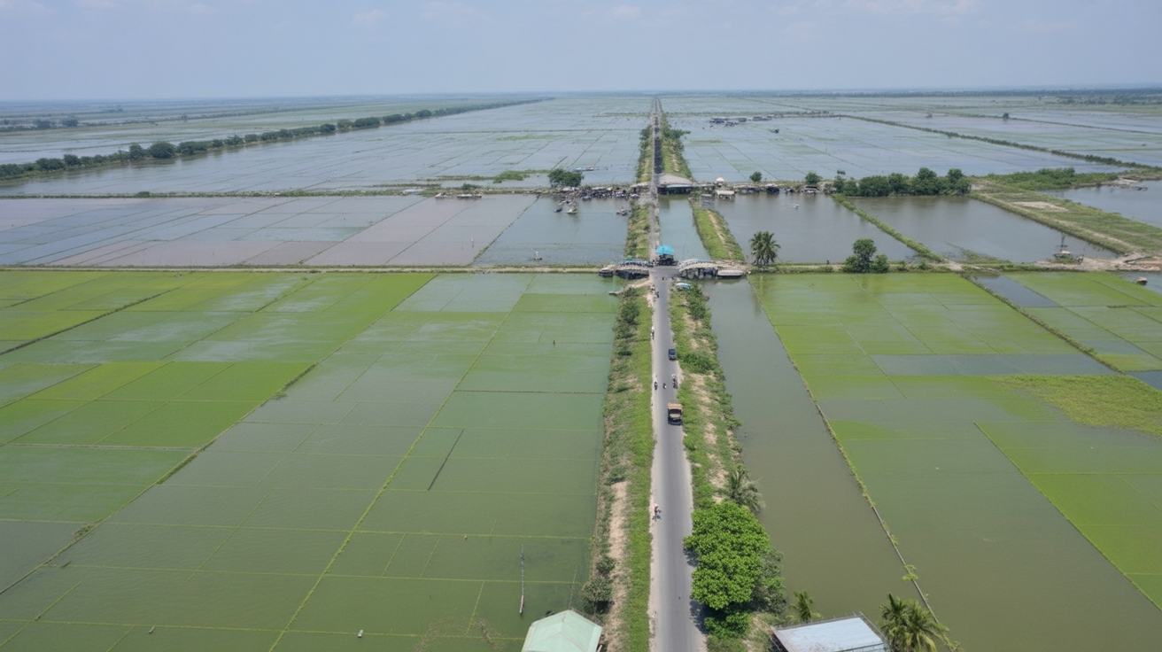
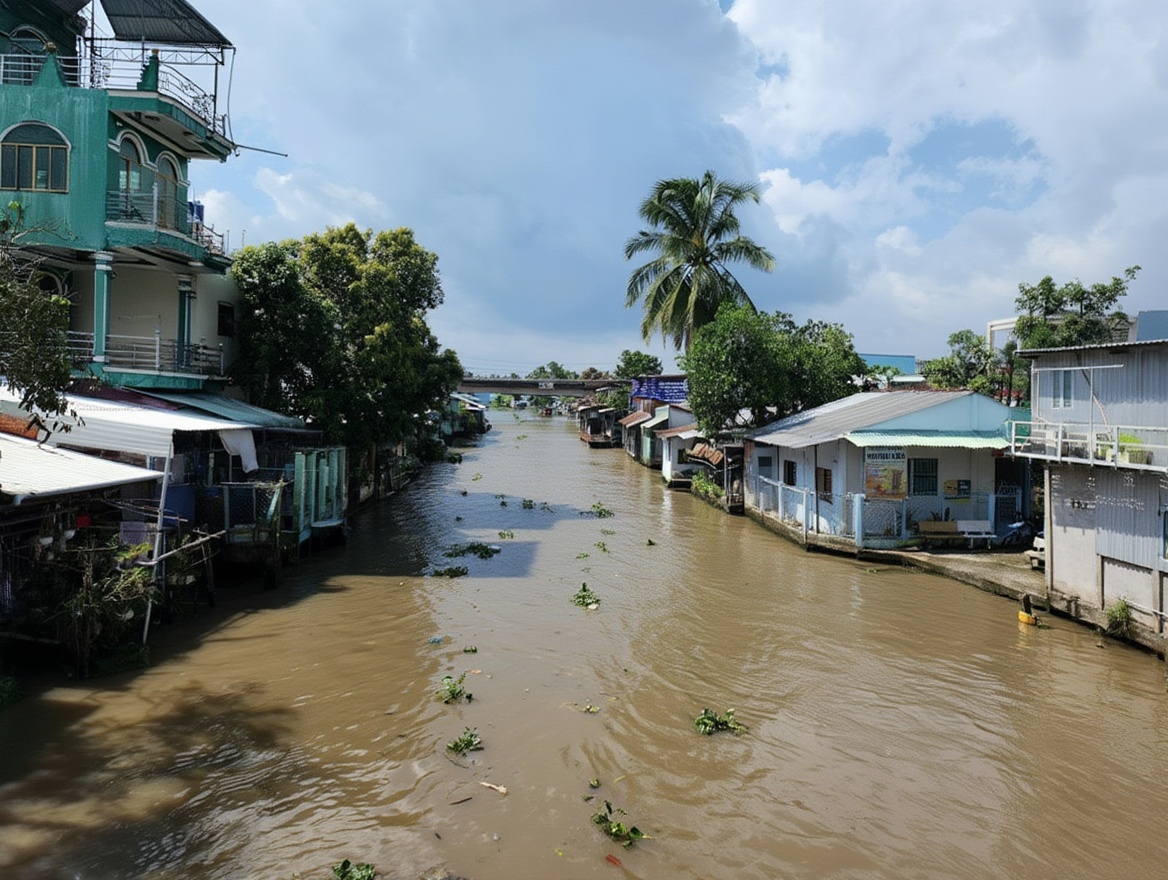
The Mekong River enters Vietnam from Cambodia as two main channels — the Tien River (sông Tiền) and the Hau River (sông Hậu) — and fans out into nine smaller rivers before reaching the sea. This creates a flat, low-lying landscape crisscrossed by 28,000km of canals, rivers, and waterways. Rice paddies, fruit orchards, brick kilns, floating villages, fish farms — this is the place that produces roughly half of Vietnam’s rice, most of its fruit exports, and a significant portion of its freshwater seafood.
The nine provinces from north to south: Long An, Tien Giang, Ben Tre, Dong Thap, Vinh Long, Tra Vinh, An Giang, Hau Giang, Soc Trang, Bac Lieu, Ca Mau, and Kien Giang. The main city is Can Tho (Cần Thơ), the capital of the delta and the only real urban hub outside Saigon’s immediate orbit.
For most travellers, the delta divides into two circuits and one hub.
Circuit 1: The Eastern Tourist Route (My Tho, Ben Tre, Can Tho)
This is the circuit 90% of Vietnam itineraries include. It’s accessible from Saigon, well-served by buses, and has the most tourist infrastructure. It’s also the most visited and — depending on your tolerance for organised tours — the most diluted.
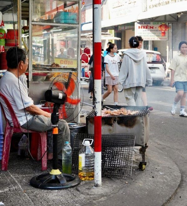
My Tho (Mỹ Tho) — 70km from Saigon, 1.5 hours by bus (50,000–70,000 VND, ~$1.90–2.70). The starting point for most Saigon day trips. The city has a genuine local life — a market, a riverside walk, solid food — but its floating market is a shadow of what it was. Worth passing through on the way to Ben Tre or Can Tho; not worth dedicating a full day to as a standalone destination.
Klook has the widest selection for Vietnam and is usually the cheapest. KKday is strong on day trips and local experiences.
Ben Tre is worth 4–6 hours: coconut product cottage industries, quieter canals than Can Tho, decent street food. The Ben Tre floating market (Chợ Nổi Cái Bè, actually in Tien Giang province nearby) is the best option for travellers who can’t make it to Can Tho.
Can Tho (Cần Thơ) — 170km from Saigon, 3.5 hours by FUTA bus. The hub. Everything in the eastern circuit leads here. The Cai Rang floating market is 6km from the city centre by boat. Stay minimum one night, ideally two. For the full Can Tho breakdown, see our Can Tho Mekong Delta guide.
Circuit 2: The Western Route (Chau Doc, Ha Tien, Phu Quoc)
Fewer travellers complete this circuit — it requires more time and takes you away from the main Vietnam north-south spine. It’s also genuinely different: flatter, quieter, closer to the Cambodian border, ending at Ha Tien where ferries cross to Phu Quoc island.
Chau Doc (Châu Đốc) — 240km from Saigon, 5–6 hours by bus. The last significant Vietnamese city before the Cambodian border. The floating village on the Hau River is a working community of several hundred households living on the water — fish farms underneath, houses above, boats as the primary transport. Sam Mountain (Núi Sam) rises abruptly from the flat delta landscape 5km from town — the climb takes 30 minutes and gives the only elevated view of the surrounding rice fields and Cambodia beyond. Border crossing to Moc Bai (Cambodia) is easy from here.
Ha Tien (Hà Tiên) — 340km from Saigon, 6–7 hours by bus. Small coastal town on the Gulf of Thailand. The ferry to Phu Quoc island leaves from Rach Gia (50km east) or Ha Tien town itself. Ha Tien has limestone karst formations similar to Ha Long Bay but almost entirely unvisited by tourists — Thach Dong cave, Mui Nai beach, the Cambodian border town of Prek Chak visible across the river. Worth one night if you’re connecting to Phu Quoc by ferry rather than flying.
The Key Routes and Distances
Which Areas to Skip and Why
The Mekong Delta is large enough that no itinerary of less than 10 days can cover it properly. Most people should pick one area and do it well rather than rushing between provinces.
Ca Mau — the southernmost tip of Vietnam, famous for mangrove forests and the point where three seas meet. It’s a genuine natural wonder. It’s also 360km from Saigon, has limited tourist infrastructure, and takes a full day to reach from Can Tho. Most travellers who go feel the journey was worth it; most travellers who research it decide it isn’t worth the time. Worth it for: people spending 7+ days in the delta, naturalists, birdwatchers, anyone with a specific interest in mangrove ecosystems.
Rach Gia — primarily a ferry terminal for Phu Quoc. Not worth a night unless you miss the evening ferry. The city functions as a port town and does it efficiently.
Sa Dec — a small town in Dong Thap province famous as the setting for Marguerite Duras’s novel The Lover. The family house still exists. Beautiful colonial architecture. Worth 3–4 hours as a detour between Can Tho and Vinh Long if you’re on the road with your own transport; not worth special routing.
What the Mekong Delta Actually Looks and Feels Like
Most travellers arrive with an image of the delta formed from photographs — green rice paddies, wooden boats on brown water, conical hats, mist. That image isn’t wrong but it’s incomplete.
The delta is flat. Completely flat. After weeks in the northern highlands or the central mountain ranges, arriving in the Mekong feels like stepping onto a different planet. No hills, no elevation, no horizon line except the palm trees. The sky takes up more of the view than the land.
The water is brown. Not turquoise, not blue — the colour of milky tea, heavy with sediment from six countries upstream. The sea at Ca Mau where the delta meets the Gulf of Thailand is naturally brown. This is the Mekong. Don’t arrive expecting clear water.
The heat is different from Saigon. More humid, slightly cooler in the shade because of the water everywhere, but there is no breeze in the interior canals. On a boat at 5am you get the river wind. On the raised canal banks at noon in March you get sunlight reflecting off water from every direction simultaneously.
The smell changes with the time of day and the wind direction. Early morning on the water: river mud, diesel, and whatever’s piled on the nearest boat — dragon fruit, coconut, fresh-cut sugarcane. At a village home stay: fish sauce, woodsmoke from a clay stove, the fermentation of the fish pond underneath the house. At the market: river fish, durian, wet concrete after the first rain of the season.
The sound that stays: the low thrum of a longtail motor at idle, rice paddies wind-ruffled in the distance, a rooster at 4am from somewhere on the canal bank, the hollow slap of a boat hull against the dock at Ninh Kieu at dawn. This is the delta’s soundtrack.
Best Time for Each Part of the Delta
The delta’s weather divides into dry season (November–April) and wet season (May–October). The difference matters more here than almost anywhere in Vietnam because flooding directly affects road and canal access.
Dry season (November–April): Best for canal cycling, walking the raised levee paths between orchards, and any activity on unpaved ground. Floating markets operate normally. Lower humidity. The delta turns a dustier shade — drier rice paddies, lower river levels, fewer of the lush greens that the wet season produces.
Wet season (May–October): The delta floods. In a good year this means ankle-deep water on the levee paths and canal banks that are navigable only by boat. In a bad year — and 2024 saw significant flooding — it means standing water in villages and some roads impassable to wheeled transport. The upside: the landscape turns extraordinary shades of green, the floating markets get more boat traffic, and fewer tourists come. This is the delta as the locals experience it.
September–October: The flood season peak. Genuinely spectacular for experienced travellers who don’t mind muddy shoes and limited mobility. Not recommended for a first visit.
Getting Around the Mekong Delta
Between cities: the FUTA / Phuong Trang bus network covers all major delta towns from Saigon’s Mien Tay terminal. Reliable, air-conditioned, cheap.
Within cities and between canal communities: hired motorbike, Grab (available in Can Tho and My Tho), bicycle, or private boat. The canal network is the primary form of local transport in the smaller communities — the roads are often raised levees barely wide enough for a motorbike. Don’t expect to navigate the smaller waterways independently without a local guide or boat operator.
12Go covers most Vietnam routes — sleeper buses, trains, and island ferries. Compare schedules and book in advance during peak season (Dec–Feb, Jun–Aug).
The full logistics breakdown — buses, departure times, what to book in advance — is in our Mekong Delta from Saigon guide.
Sample Itineraries by Time Available
1 night / 2 days: Saigon → Can Tho by afternoon bus. Ninh Kieu wharf evening. Wake 4:30am → Cai Rang floating market by boat → canal detour → breakfast. Bus back to Saigon by noon. Total cost excluding accommodation: ~$15–25.
3 nights / 4 days: Day 1: Saigon → Ben Tre (tour the coconut province, overnight). Day 2: Ben Tre → Can Tho. Day 3: Can Tho floating market dawn + canal cycling. Day 4: Can Tho → Vinh Long → Saigon. This is the most common tourist loop and it works.
5 nights / 6 days: Add Chau Doc (floating village, Sam Mountain) and Ha Tien onto the 3-night loop. Exit via Ha Tien ferry to Phu Quoc rather than returning to Saigon. This is the most logical routing if Phu Quoc is on your itinerary.
The Island Districts — Where the Real Delta Hides
Between the provinces, the Mekong creates dozens of islands — some large enough to have their own towns, some just long, thin strips of land between two channels. These islands are where the delta’s agricultural and fishing economy most visibly operates, and they’re almost completely off the standard tourist circuit.
Cồn Thới Sơn — an island in the Tien River accessible by short ferry from My Tho. A few hundred metres wide, several kilometres long, entirely covered in fruit orchards: longan, rambutan, jackfruit, coconut. Bicycles available to rent. The tourist circuit stops at a few designated orchards; keep cycling past them and the island becomes genuinely quiet and local within 15 minutes.
An Binh Island (near Vinh Long) — larger than Thoi Son, with a network of raised canal paths through fruit farms and brick kilns. Vinh Long’s brick kilns are a visual signature of the central delta — tall chimneys rising from the flat landscape, boats being loaded with fired bricks at the river bank. This industry has been running since the early 20th century and still operates at scale.
Cồn Phụng (Coconut Monk Island, near My Tho) — a tiny religious site built by a monk called Nguyễn Thành Nam who spent decades on a platform in the middle of the river. The architectural remnants are genuinely strange — dragon staircases, towers, a concrete relief map of Vietnam. Small ferry from My Tho, 30 minutes. Worth including in a My Tho stop as a curiosity.
The delta’s island geography is why the map matters more here than in other parts of Vietnam. A route that looks linear on paper involves ferries, narrow canal crossings, and paths that only exist at low water. Always verify the current route with locals or guesthouse staff before committing to a cycling route that crosses multiple islands.
What I Got Wrong About the Mekong Delta Map
My first time planning the delta, I looked at the map and thought: it’s not that big. I can cover My Tho, Can Tho, Chau Doc, and Ha Tien in four days. Manageable.
What I hadn’t accounted for: the roads in the delta aren’t straight. The canals mean constant bridges and detours. A 120km route on the map takes 2.5 hours not because of traffic but because you’re crossing the same river three times from different directions. The distances are real but the roads aren’t highways.
The right way to read the Mekong Delta map is not as a road map but as a network — which nodes connect to which, which buses run direct, and which routes require a transfer. Once you understand that, the delta becomes navigable.
Two things worth sorting before you land: a Vietnam eSIM so you have data the moment you clear customs, and travel insurance — medical costs for uninsured foreigners in Vietnam are significant.
Airalo eSIMs activate instantly. Buy before departure — airport SIM queues in Vietnam can take 30+ minutes.
Frequently Asked Questions
Can I do the Mekong Delta without a guide?
Yes, for the bus-connected towns (My Tho, Can Tho, Chau Doc, Ha Tien). The intercity buses are reliable, the guesthouses in Can Tho speak basic English, and the boat operators at Ninh Kieu wharf hire independently. A guide adds value for the smaller canal communities and rural cycling routes where language becomes a barrier. For the standard eastern circuit — Saigon, My Tho, Ben Tre, Can Tho — no guide is necessary.
✓Quick Answer
You don’t need a guide for the main Mekong Delta towns. The FUTA bus connects Saigon to Can Tho in 3.5 hours for 130,000 VND (~$5). Boat operators at Ninh Kieu wharf hire independently. A guide is only necessary for the deeper canal network and rural communities off the main bus routes.
Is the Mekong Delta worth it for a 2-week Vietnam trip?
Yes — 2–3 nights is the right allocation. One night minimum if you’re time-pressured. The Mekong Delta is fundamentally different from central and northern Vietnam — flatter, hotter, slower, more water-focused. It rounds out a Vietnam trip in a way that otherwise gets missed.
Is the Mekong Delta safe to travel independently?
Yes. The major towns — Can Tho, My Tho, Chau Doc — are straightforward. The buses are reliable and cheap. The main safety consideration is traffic on the canal paths: narrow raised levees with motorbikes coming the other way at speed, especially after rain when the surface is slick. Slow down on muddy paths. The Mekong Delta has no meaningful crime targeting tourists beyond the standard overpricing that applies everywhere in Vietnam.
Do I need cash in the Mekong Delta?
Yes, more than in Saigon. ATMs exist in Can Tho, My Tho, and Chau Doc. In smaller towns and canal communities, there are no card readers and no ATMs. Carry enough cash for boat hire, street food, accommodation, and bus tickets from any point in the delta. A reasonable float: 500,000–800,000 VND (~$19–30) per day in cash should cover everything including one boat trip.
Can I see the floating markets without joining a tour?
Yes, at Cai Rang (near Can Tho). Walk to Ninh Kieu wharf at 4:30am, find a boat operator, agree a price (350,000–500,000 VND, ~$13–19 for a 2-hour private boat), and go. No travel agent required. The My Tho floating market — such as it is — is accessible via the day-trip circuit from Saigon, but the boats are mostly empty and the experience is curated. Cai Rang is the one worth getting up early for.
What’s the difference between the Mekong Delta and the Mekong River?
The Mekong River is the 4,350km river that runs from Tibet through China, Myanmar, Laos, Thailand, and Cambodia before reaching Vietnam. The Mekong Delta is the 40,000km² area where it fans out and meets the sea — nine distributaries, thousands of canals, and the most productive agricultural land in Vietnam. The delta’s brown water comes from sediment carried from 6 countries upstream.
Is it possible to cross from the Mekong Delta into Cambodia?
Yes — the Moc Bai border crossing (90km from Saigon) and the Vinh Xuong crossing near Chau Doc are both open to tourists. The Chau Doc–Phnom Penh fast boat route is a popular option: departs Chau Doc early morning, arrives Phnom Penh in approximately 5 hours, costs around 600,000–750,000 VND (~$23–28). The boat crosses into Cambodia on the Mekong — a genuinely good way to leave Vietnam if your route is heading north through Cambodia. Buy tickets at guesthouses in Chau Doc the night before; booking is essential in high season (December–January).
How does the Mekong Delta compare to other parts of southern Vietnam?
The delta is slower, cheaper, and more agricultural than Saigon, the coast, or Phu Quoc. It doesn’t have beaches. It doesn’t have significant historical monuments. What it has is a working landscape that produces most of Vietnam’s food — rice, fruit, fish — and a canal network that, when you’re on a boat at 5am watching it wake up, feels completely unlike anywhere else in the country. It’s worth 2–3 nights of any Vietnam itinerary that has the time.
FAQ
How do I navigate the Mekong Delta without getting lost?
The Mekong Delta’s waterways are the main transport arteries — roads and canals often run parallel. Key navigation: Google Maps works reasonably well on roads but doesn’t map canals. For boat-based exploration, hire a local guide with a sampan rather than renting and navigating yourself. The main tourist circuit (Can Tho, My Tho, Ben Tre) is well-signposted.
What is the best base for exploring the Mekong Delta?
Can Tho for the floating markets (Cai Rang) and western delta. My Tho for day-trippers from Saigon (closest delta city, 70km). Ben Tre for coconut island and quieter canal networks. Chau Doc for the Cambodia border crossing and Sam Mountain. Most travelers based in Can Tho can access all the main delta attractions within a half-day drive or boat trip.
Can you rent a motorbike and explore the Mekong Delta?
Yes — this is one of the best ways to see the delta properly. The flat terrain and secondary roads between Can Tho and Ben Tre are ideal for motorbike exploration. Google Maps works for navigation. The main challenge is finding your way when GPS signal drops near the smaller canal communities. A printed or downloaded offline map is useful.
How many days do you need in the Mekong Delta?
Minimum 2 nights based in Can Tho to hit the Cai Rang floating market and do a half-day canal boat tour. Add a third night if you want to visit My Tho or Ben Tre. Four to five days if you want to go deeper into the delta toward Chau Doc and the Cambodia border. Day trips from Saigon see almost nothing real — the delta requires staying overnight.
What is the best time to visit the Mekong Delta?
November to April — the dry season, when roads are passable and the flat delta landscape is green. The rainy season (May–October) floods low-lying roads and makes some canal areas inaccessible by anything except boat. The annual flood season (September–October) actually creates a different landscape worth seeing if you’re flexible about travel conditions.